Local Legends of a Sacred Cave
near Rennes-les-Bains ...?
Catel - in his Mémoires de l'histoire du Languedoc [published in 1633] is the first to mention a curious stone found in the church at Rennes-les-Bains. He wrote:
"we can still see in the church of les Bains de Rennes, this ancient Roman inscription which had been recovered back in the old days from the ancient buildings round the fontaine/source,
C. POMPEIVS QVARTVS, P.A. M. SVO".
How far back in the old days was Catel referring to? With such antiquity we must assume relic hunters were digging up Rennes many years prior to 1626. This proves the remarkable interest expressed in Rennes-les-Bains in the sixteenth and seventeenth century's - there are reports of many artifacts and ancient coins being found on the territory of the commune. For example, around 100 years after Catel, Antoine Delmas, priest of Rennes-les-Bains, confirms the presence of this same pedestal in his office. The local clergy were not the only ones interested in the area. Outside the circle of the parish priests, Alexandre Du Mege (1780-1862) reported that Abbe Bertrand Capmartin of Chaupy (1720-1798), an archaeologist born near Toulouse, had recovered more than 400 gold and silver coins in the region of Rennes! Du Mege, who had often stayed in Rennes-les-Bains, spoke of counselors at the Parliament of Toulouse who had found medals and coins at Rennes. Jean-François de Montegut (1729-1794), from a family of collectors and a scholar himself, had more than 3,000 Roman coins including many from Rennes-les-Bains. The priest Delmas even offered a beautiful sepulchral lamp to the President of the Parliament of Toulouse, M. Caulet! Paul Urban Villecardet, Count of Fleury (1778-1836) had a nice collection of coins and medals, objects that he had put into a small personal museum he created. He had asked Du Mege to help him appraise all of the artifacts. In 1857, his own son Henri-Paul Elie was awarded the Silver Medal of the Imperial Academy of Sciences, Inscriptions and Belles-lettres de Toulouse for his discoveries at Rennes-les-Bains - and for his preservation of two wheels and various fragments of a bronze chariot found in the territory of the commune. Was this the city of chariots indeed?
We should note that Alfred Sauniere [brother of Berenger] was a member of the Archaeological Committee of Narbonne and that Henri Boudet knew Henri Rouzaud who was President of this Committee. Mr. Rouzaud made many study trips to Rennes-les-Bains and Boudet had offered him several objects discovered on the territory of the parish: Vases, pottery and even a beautiful gourd dated to the fifth or sixth century. Where did Henri Boudet make such finds? (see HERE). Accidentally or did he know the whereabouts of some archaeological site - perhaps deeply hidden?
It is within this backdrop of discoveries then that the Roman Quartus stone was equated with a tomb of an important Roman perhaps buried at Rennes. More or less at the same time - legends surface about a spectacular find in and around Rennes, linked specifically to Blaise D'Hautpoul and Nicolas Pavillon, the very famous and notorius Bishop of Alet. Delmas had been made a priest by Pavillon in 1699, eight years after Pavillon had been involved in an aggressive court case brought against him by the above cited Blaise. Blaise had had the church at Rennes-le-Chateau restored. In this endeavour he was helped by Pavillon. In November 1661 - Blaise went to court against Pavillon, to prevent the Kings troops searching and trampling over his lands and mines. Those lands and possessions included Rennes, St Just, Le Bezu, les Bains (Rennes-les-Bains), Montferrand, Montazels and La Val Dieu. The long and complex trial ended in April 1666 to the advantage of Pavillon but only after King breaks the judgments in favour of the bishop. More than one researcher has asked whether the finds at Rennes and later legends are somehow related to this court case.
Two hundred years later Boudet, a later priest of Rennes-les-Bains, writes a book about a mysterious tomb in the area of Rennes-les-Bains. Even later a mystery surrounds the burial of Marie de Negre - the last member in the line of the Hautpoul family who could trace her line directly back to Blaise d'Hautpoul.
Swirling around all these events are the themes of a burial, a Roman and a treasure, ancient mines and family property on the commune. Are events connected or is it just wishful thinking?
The Wandering Stone
We know Catel's Quartus 'stone' had a wandering history. Originally it had been taken from the ancient buildings that surrounded the fontaine of Rennes-les-Bains and was moved to the church (or vestry) in the village. In 1709 it was described by Delmas as being in the cabinet of the curé at the time. Circa. 1760 it was bought in Rennes-les-Bains by the seigneur of the Château du Vivier and then taken to Le Vivier (just down the road in the Fenouillèdes, in the canton of Sournia). Then it was taken from the château du Vivier (or bought) by M. Barrot the notaire at Sournia. It ended up in the hands of M. de Montagnas who in turn presented it to the museum of Perpignan where it was seen and described by M. Puiggari in 1832. By now the stone was being called a 'cippe' - no doubt because Delmas had associated the inscription with some sort of tomb marker. Still for others it was reported that the stone had been lost and did not exist anymore.
However it is with Abbe Delmas [although which one researchers are not clear about] that the idea of an important burial first appears. This was detailed in the Delmas manuscript called 'Antiquities of the Commune of the Bains de Montferran called Bains de Rennes'. We know he is talking about the Baths of Rennes and in particular it's Roman history - the baths having been built on top of a probably preexisting site of sacred importance. The real question is why did Delmas equate the Quartus stone with a burial - no less with an important Roman associated with Pompey?
Four things of importance in our present context which Delmas mentions in his manuscript are as follows:
1] The stone 'whose inscription marks its antiquity'. Delmas offers various interpretations of this inscription up to his time, finally concluding that it is a 'tombstone' that refers to Pompey, or Pompey's sons, or a very good friend of Pompey's who would have died in Gaul.
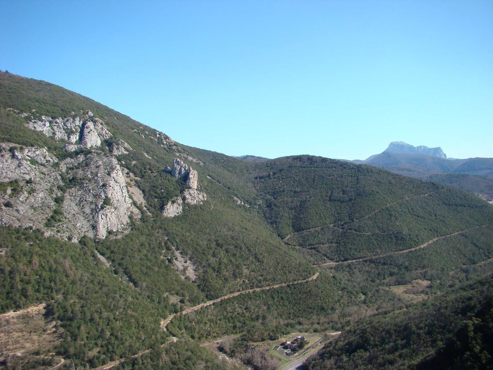
Pompey is known to have passed through Spain and antique Gaul. There is even a Trophy of Pompey [see reconstructed trophy in picture below]. The Domitian Way, created in 118 BC was retained entirely within the width of the Trophy of Pompey and its environs. This ancient 'way' was itself a main artery. The foundations of the Pompey trophy were built to accommodate large sandstone blocks. In the northeast corner, the trenches were installed in "tiers" - a technique inherited from the Greeks and used by the Romans until the time of Augustus. This is the first example of this type of monumental construction celebrating the supremacy of Rome over the Mediterranean and thus European world.
2] 'Pieces of urns' which can be found in abundance [at Rennes-les-Bains]. Delmas reports;
"... because these urns are only earthenware, it could be surmised that they are older than the Roman times, for Ceasar tells us in his book 8 of the De Bello Gallorum, that it was the custom of the Gauls to burn their dead, and we have learned since that the Asiatic peoples took up the same custom, which did not become established among the Romans until the time of Sulla...' [Lucius Cornelius Sulla Felix c. 138 BC – 78 BC), known commonly as Sulla, was a Roman general and statesman].
3] The seventh Roman legion was established at Beziers & those who lived at Bains were drawn from this legion. These colonies were established on the land of the Volques Tectosages, at the time of Quintus Fabius Maximus [Some time prior to 48 BC, Maximus was elected Praetor. In 46 BC, he was one of Julius Caesar's legates who fought in the civil war. Maximus was sent by Caesar to Hispania along with Quintus Pedius in command of the troops sent from Sardinia to deal with the Pompeians, who were led by Gnaeus Pompeius [ie Pompey], after having surpressed the Salians..... for some time Augustus Ceasar was settled at Narbonne and it is believed that a medallion of an offering to Aesculapius - for the health of Augustus, who was ill at Narbonne, was found here.
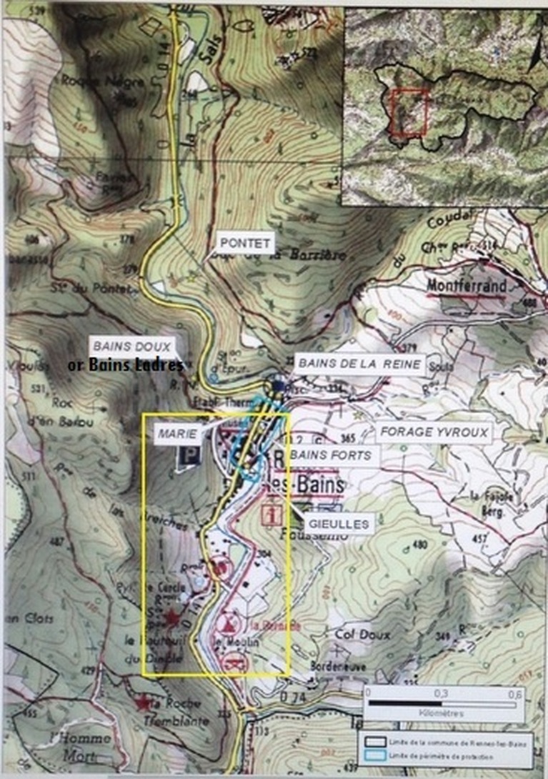
4] During the time of Delmas, and which he mentions, were two sources of 'lukewarm' water at Rennes. One was called the Bains de la Reine, the other Bains de Ladres. Delmas said that the size of the baths of the Bains de la Reine [Reynes] were almost the same size of those of the Ladres. He then writes 'along the length of the river the place where one bathes is paved with huge stones chased with little bits of marble, the length and width of a little finger, in the form of a mosaic. The priest has some of these paved stones in his study. High up towards the mountain there are the marks of a number of small rooms, which were apparently the apartments ... from time to time large pieces of marble, both white and black, have been picked up despite there being no marble quarry open in this country'.
"we can still see in the church of les Bains de Rennes, this ancient Roman inscription which had been recovered back in the old days from the ancient buildings round the fontaine/source,
C. POMPEIVS QVARTVS, P.A. M. SVO".
How far back in the old days was Catel referring to? With such antiquity we must assume relic hunters were digging up Rennes many years prior to 1626. This proves the remarkable interest expressed in Rennes-les-Bains in the sixteenth and seventeenth century's - there are reports of many artifacts and ancient coins being found on the territory of the commune. For example, around 100 years after Catel, Antoine Delmas, priest of Rennes-les-Bains, confirms the presence of this same pedestal in his office. The local clergy were not the only ones interested in the area. Outside the circle of the parish priests, Alexandre Du Mege (1780-1862) reported that Abbe Bertrand Capmartin of Chaupy (1720-1798), an archaeologist born near Toulouse, had recovered more than 400 gold and silver coins in the region of Rennes! Du Mege, who had often stayed in Rennes-les-Bains, spoke of counselors at the Parliament of Toulouse who had found medals and coins at Rennes. Jean-François de Montegut (1729-1794), from a family of collectors and a scholar himself, had more than 3,000 Roman coins including many from Rennes-les-Bains. The priest Delmas even offered a beautiful sepulchral lamp to the President of the Parliament of Toulouse, M. Caulet! Paul Urban Villecardet, Count of Fleury (1778-1836) had a nice collection of coins and medals, objects that he had put into a small personal museum he created. He had asked Du Mege to help him appraise all of the artifacts. In 1857, his own son Henri-Paul Elie was awarded the Silver Medal of the Imperial Academy of Sciences, Inscriptions and Belles-lettres de Toulouse for his discoveries at Rennes-les-Bains - and for his preservation of two wheels and various fragments of a bronze chariot found in the territory of the commune. Was this the city of chariots indeed?
We should note that Alfred Sauniere [brother of Berenger] was a member of the Archaeological Committee of Narbonne and that Henri Boudet knew Henri Rouzaud who was President of this Committee. Mr. Rouzaud made many study trips to Rennes-les-Bains and Boudet had offered him several objects discovered on the territory of the parish: Vases, pottery and even a beautiful gourd dated to the fifth or sixth century. Where did Henri Boudet make such finds? (see HERE). Accidentally or did he know the whereabouts of some archaeological site - perhaps deeply hidden?
It is within this backdrop of discoveries then that the Roman Quartus stone was equated with a tomb of an important Roman perhaps buried at Rennes. More or less at the same time - legends surface about a spectacular find in and around Rennes, linked specifically to Blaise D'Hautpoul and Nicolas Pavillon, the very famous and notorius Bishop of Alet. Delmas had been made a priest by Pavillon in 1699, eight years after Pavillon had been involved in an aggressive court case brought against him by the above cited Blaise. Blaise had had the church at Rennes-le-Chateau restored. In this endeavour he was helped by Pavillon. In November 1661 - Blaise went to court against Pavillon, to prevent the Kings troops searching and trampling over his lands and mines. Those lands and possessions included Rennes, St Just, Le Bezu, les Bains (Rennes-les-Bains), Montferrand, Montazels and La Val Dieu. The long and complex trial ended in April 1666 to the advantage of Pavillon but only after King breaks the judgments in favour of the bishop. More than one researcher has asked whether the finds at Rennes and later legends are somehow related to this court case.
Two hundred years later Boudet, a later priest of Rennes-les-Bains, writes a book about a mysterious tomb in the area of Rennes-les-Bains. Even later a mystery surrounds the burial of Marie de Negre - the last member in the line of the Hautpoul family who could trace her line directly back to Blaise d'Hautpoul.
Swirling around all these events are the themes of a burial, a Roman and a treasure, ancient mines and family property on the commune. Are events connected or is it just wishful thinking?
The Wandering Stone
We know Catel's Quartus 'stone' had a wandering history. Originally it had been taken from the ancient buildings that surrounded the fontaine of Rennes-les-Bains and was moved to the church (or vestry) in the village. In 1709 it was described by Delmas as being in the cabinet of the curé at the time. Circa. 1760 it was bought in Rennes-les-Bains by the seigneur of the Château du Vivier and then taken to Le Vivier (just down the road in the Fenouillèdes, in the canton of Sournia). Then it was taken from the château du Vivier (or bought) by M. Barrot the notaire at Sournia. It ended up in the hands of M. de Montagnas who in turn presented it to the museum of Perpignan where it was seen and described by M. Puiggari in 1832. By now the stone was being called a 'cippe' - no doubt because Delmas had associated the inscription with some sort of tomb marker. Still for others it was reported that the stone had been lost and did not exist anymore.
However it is with Abbe Delmas [although which one researchers are not clear about] that the idea of an important burial first appears. This was detailed in the Delmas manuscript called 'Antiquities of the Commune of the Bains de Montferran called Bains de Rennes'. We know he is talking about the Baths of Rennes and in particular it's Roman history - the baths having been built on top of a probably preexisting site of sacred importance. The real question is why did Delmas equate the Quartus stone with a burial - no less with an important Roman associated with Pompey?
Four things of importance in our present context which Delmas mentions in his manuscript are as follows:
1] The stone 'whose inscription marks its antiquity'. Delmas offers various interpretations of this inscription up to his time, finally concluding that it is a 'tombstone' that refers to Pompey, or Pompey's sons, or a very good friend of Pompey's who would have died in Gaul.
Pompey is known to have passed through Spain and antique Gaul. There is even a Trophy of Pompey [see reconstructed trophy in picture below]. The Domitian Way, created in 118 BC was retained entirely within the width of the Trophy of Pompey and its environs. This ancient 'way' was itself a main artery. The foundations of the Pompey trophy were built to accommodate large sandstone blocks. In the northeast corner, the trenches were installed in "tiers" - a technique inherited from the Greeks and used by the Romans until the time of Augustus. This is the first example of this type of monumental construction celebrating the supremacy of Rome over the Mediterranean and thus European world.
2] 'Pieces of urns' which can be found in abundance [at Rennes-les-Bains]. Delmas reports;
"... because these urns are only earthenware, it could be surmised that they are older than the Roman times, for Ceasar tells us in his book 8 of the De Bello Gallorum, that it was the custom of the Gauls to burn their dead, and we have learned since that the Asiatic peoples took up the same custom, which did not become established among the Romans until the time of Sulla...' [Lucius Cornelius Sulla Felix c. 138 BC – 78 BC), known commonly as Sulla, was a Roman general and statesman].
3] The seventh Roman legion was established at Beziers & those who lived at Bains were drawn from this legion. These colonies were established on the land of the Volques Tectosages, at the time of Quintus Fabius Maximus [Some time prior to 48 BC, Maximus was elected Praetor. In 46 BC, he was one of Julius Caesar's legates who fought in the civil war. Maximus was sent by Caesar to Hispania along with Quintus Pedius in command of the troops sent from Sardinia to deal with the Pompeians, who were led by Gnaeus Pompeius [ie Pompey], after having surpressed the Salians..... for some time Augustus Ceasar was settled at Narbonne and it is believed that a medallion of an offering to Aesculapius - for the health of Augustus, who was ill at Narbonne, was found here.
4] During the time of Delmas, and which he mentions, were two sources of 'lukewarm' water at Rennes. One was called the Bains de la Reine, the other Bains de Ladres. Delmas said that the size of the baths of the Bains de la Reine [Reynes] were almost the same size of those of the Ladres. He then writes 'along the length of the river the place where one bathes is paved with huge stones chased with little bits of marble, the length and width of a little finger, in the form of a mosaic. The priest has some of these paved stones in his study. High up towards the mountain there are the marks of a number of small rooms, which were apparently the apartments ... from time to time large pieces of marble, both white and black, have been picked up despite there being no marble quarry open in this country'.
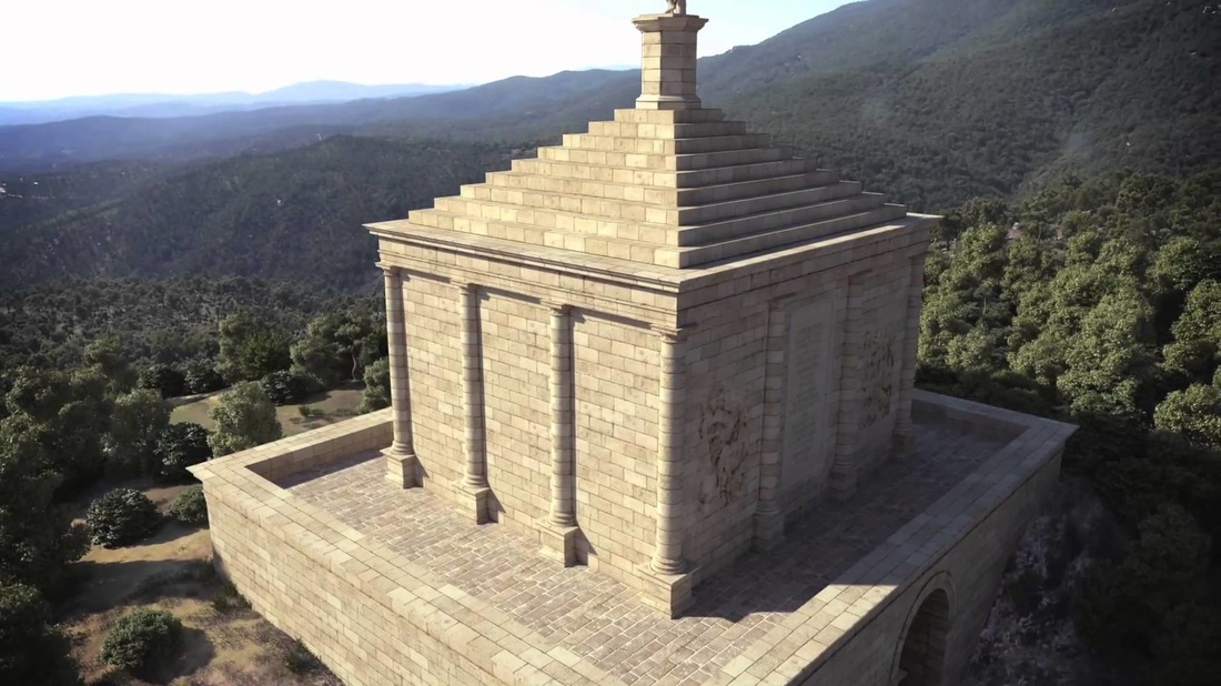
the reconstructed Trophy of Pompey and its environs
From all of this we can surmise that - for Delmas - the following is of relevance:
So if we follow the river at these sources might we see evidence of the mosaics - coloured black and white?
The Priory of Sion
In Le Serpent Rouge the author writes:
"Les dalles du pavé mosaïque du lieu sacré pouvaient-être alternativement blanches ou noires..." which means "The stones of the mosaic paving of the sacred place could be alternatively black or white...".
Is it possible that the 'stones of the mosaic paving of the sacred place' be consistent with the details supplied by Delmas? Delmas had identified the land and river along the Bains de la Reyne and the Bains Ladres as having possibly mosaics of marble, black and white but it appears only that the Bains Doux baths fit the description regarding the "rooms associated with the Baths" which were high up the mountain - illustrated perfectly in the picture below.
- there might be an important burial in the environs of Rennes-les-Bains.
- the land originally belonged to the Tectosages, those ancient Gauls, who burnt their dead.
- the land was taken from them by the Romans.
- Roman soldiers of the 7th Legion settled there and built the baths up.
- two bath sources, that of the Reine, and that of the Ladres, along the banks of the river had evidence of mosaics and marble, coloured black and white. High up in the mountains are the rooms associated with the Baths.
So if we follow the river at these sources might we see evidence of the mosaics - coloured black and white?
The Priory of Sion
In Le Serpent Rouge the author writes:
"Les dalles du pavé mosaïque du lieu sacré pouvaient-être alternativement blanches ou noires..." which means "The stones of the mosaic paving of the sacred place could be alternatively black or white...".
Is it possible that the 'stones of the mosaic paving of the sacred place' be consistent with the details supplied by Delmas? Delmas had identified the land and river along the Bains de la Reyne and the Bains Ladres as having possibly mosaics of marble, black and white but it appears only that the Bains Doux baths fit the description regarding the "rooms associated with the Baths" which were high up the mountain - illustrated perfectly in the picture below.
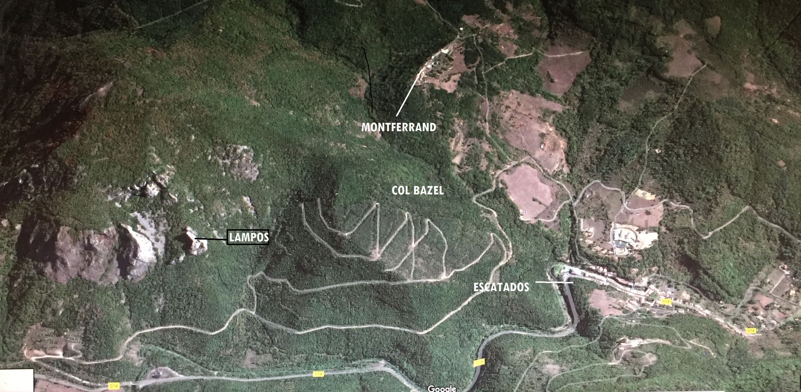
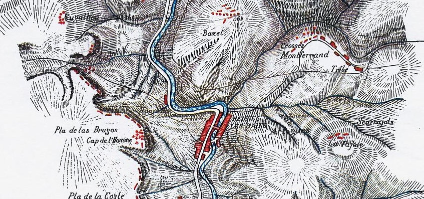
In the map below you can see the other main points of sources of water in regards to the statements made by Delmas.
In this general area a French researcher, writing on the subject, said that "L'ancien village de RLB situé vers le Bazel et les ancien thermes ont été décrits' which means "The former village of RLB [was originally] located towards Bazel and the old baths have been described' [Urbain de Larouane]. We can see that Bains Ladres was not far from Bazel. Larouane then described a "salle carrelée de la source de la Saponaire, amphores romaines" which means 'a tiled room of the source of the Saponaire [cockle], [with] Roman amphorae".
Although i have only recently read about this mysterious 'cave' it seems it is pretty well known to other researchers. Another commentator had mentioned a room such as this. Vits wrote: Just a short distance from Cassaignes, on the Col de Bazel, next to the mountain full of mystey, the Cardou, is a place full of Roman amphorae. There appears [here to have] been a warehouse during the Gallo-Roman epoch. ..... Such "amphorae" are not uncommon in the area. Practically throughout the valley, in which flows through the Sals, the remnants of ancient pottery and storage places are found in great concentrations. Archaeologists, amateur explorers and treasure hunters, at Rennes-les-Bains, at Sougraigne and [elsewhere have found them]. ... it is closely related to salt production, which has always been a significant economic factor in the region. The Romans used the Sals for preserving meat, fish, vegetables .. And testifying to this is the large amounts of preserved oysters in mountains of ancient shells, which can be often found in the immediate vicinity of ceramic items. This is explained by a cryptic note of Abbé Henri Boudet, a man who is seen as a key figure within the mysteries of Rennes-le-Château. To the place, at the Col de Bazel, one can best reach the narrow path from Montferrand, which passes near the entrance to the legendary Gold mine of Captain Boyer".
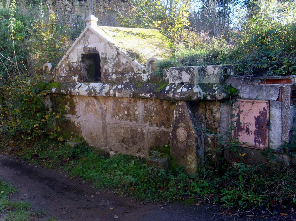
The legendary Boyer mine is pictured below. It might be part of an important mine group about 200 meters from the village of Montferrand, near the stream.
It is mentioned in the Fleury/Dubosc archives, where they state that the mine workings are ancient and attributed to the Romans or to the Maures. There are iron rail tracks inside and outside for the wagons (rhedæ) that transported the copper and iron that came from this mountain.
Although i have only recently read about this mysterious 'cave' it seems it is pretty well known to other researchers. Another commentator had mentioned a room such as this. Vits wrote: Just a short distance from Cassaignes, on the Col de Bazel, next to the mountain full of mystey, the Cardou, is a place full of Roman amphorae. There appears [here to have] been a warehouse during the Gallo-Roman epoch. ..... Such "amphorae" are not uncommon in the area. Practically throughout the valley, in which flows through the Sals, the remnants of ancient pottery and storage places are found in great concentrations. Archaeologists, amateur explorers and treasure hunters, at Rennes-les-Bains, at Sougraigne and [elsewhere have found them]. ... it is closely related to salt production, which has always been a significant economic factor in the region. The Romans used the Sals for preserving meat, fish, vegetables .. And testifying to this is the large amounts of preserved oysters in mountains of ancient shells, which can be often found in the immediate vicinity of ceramic items. This is explained by a cryptic note of Abbé Henri Boudet, a man who is seen as a key figure within the mysteries of Rennes-le-Château. To the place, at the Col de Bazel, one can best reach the narrow path from Montferrand, which passes near the entrance to the legendary Gold mine of Captain Boyer".
The legendary Boyer mine is pictured below. It might be part of an important mine group about 200 meters from the village of Montferrand, near the stream.
It is mentioned in the Fleury/Dubosc archives, where they state that the mine workings are ancient and attributed to the Romans or to the Maures. There are iron rail tracks inside and outside for the wagons (rhedæ) that transported the copper and iron that came from this mountain.
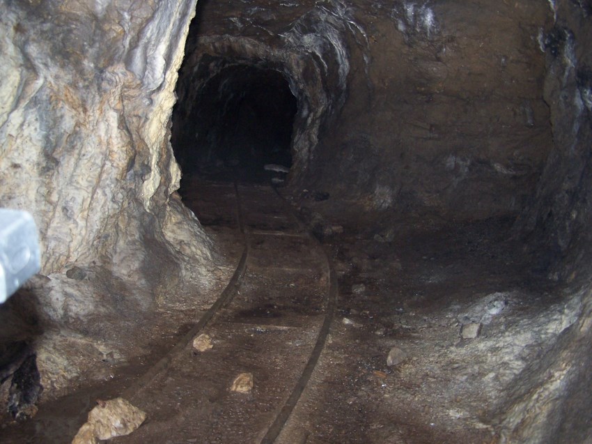
Boyer mine
It would seem Boudet attached importance to this area too. He wrote in Chapter VIII of the 'True Celtic Language' about a Gallic village at a place called Artigues - in southern Monferrand slightly below/by the stream of Dous.
"In the resort town of Rennes, of the hot spring source, the Celts were most used to the Reine or Renne. By following the chain of traditions on the effectiveness of the water of the Redones, the Romans believed that they had to build their spas to the sources and then lavish buildings, which we see still vestiges, high up in the valley of the Sals. Well before the possession of the land by the Romans, the Gauls homes were developed, as now, & grouped near the hot springs, and were built on the slope appointed Artigues - hearth (Harth), fireplace, - to eke (ike), develop. The term Tribe. - Tribe (traïbe), tribe, tribe, peoples -; designating land located south of Montferrand, testifies that the bulk of the population lived in the valley in which flows the stream of Coume. The stream of Alby - hall. dwelling - by (bai) next - which flows into that of Coume, crossed the Gallic village. Close to Artigues and above the Bugat, part of the land is named scarrajols - square (skouère) square - rash, flow - hall (haull), home".
For Boudet the Redones were very important. The word is a Gallic ethnonym composed of red - and -ones, the meaning and spelling of red - could refer either to a carriage (as Raeda ) or jumper/horse rider. Raeda = a chariot with four wheels. It can also mean, according to an obsolete meaning of the word - "the measure of stones"! Boudet may have been tapping into the obsolete meaning of the word as experts in 'measuring stones' when he wrote that the Redones formed a religious tribe, learned, possessing the secret of the elevation of megalithic monuments scattered throughout Gaul; it was the tribe of the learned stones, read (red) scholar, hone, cut stone. .' thus Read [red] hone - phonetically Redones!
Boudet later insists the Cromlech of Rennes-les-Bains was built by these Redones!
We know that Boudet was playing around with language. He never really talks about the 'true' Celtic language as the title of his book proclaims. Firstly he rather bizarrely begins with the Languedocian 'dialect' to discover the 'true Celtic language'. Why should he choose the Languedocian dialect, over say the Breton language, to find the real Celtic language? Then he switches his attention to the Volcae Tectosages - their emigrations and their history. He asserts that the Tectosages at one time possessed the island of Britain and that the later Saxons were direct descendants of the Tectosages. Boudet lists some Languedocian terms which he says are close in make up to Anglo-Saxon words to prove his thesis. After this list he says - "This indisputable relationship between Languedocian terms and Anglo-Saxon terms shows better than any reasoning that the Tectosages of the Gallic south, who had emigrated to beyond the Rhine and the Anglo-Saxons are indeed the same people".
It seems to me that Boudet is doing two things. Firstly there is a definite history of southern Gaul that he wants his readers to focus on. He also mentioned the Rhedones were the builders of the Cromleck - [bizarre because his imaginary cromleck is made from natural features] - & by referring to the local builders Boudet seems to be establishing some sort of pedigree for the Cromleck. Concurrently he is also giving us a geographic description - i.e. a map on the ground.
At the same time Boudet also suggests that all this is just a device he uses when talking about the history of his village. He told us as much when he instructs us that what his book is really about is to 'penetrate the secret of a local history by the interpretation of a name written in an unknown language'. The unknown language for him isn't even the Celtic language. It is the Punic language, not the old language of Carthage but the form of word play that suggests two or more meanings, by exploiting multiple meanings of words, or of similar-sounding words, for an intended humorous or rhetorical effect. These ambiguities can arise from the intentional use of homophonic, homographic, metonymic, or figurative language. A pun involves expressions with multiple correct interpretations. Puns may be regarded as in-jokes or idiomatic constructions, as their usage and meaning are specific to a particular language and its culture. Boudet was using the 'idiomatic constructions' for a message he wanted to convey!
He says "...Notice how easily the Punic language, through a play on words, is able to synthesis mens names. Common nouns also offer similar combinations, and represent, in several associated monosyllables, complete sentences in a rigorous and precise way. We shall choose several of these expressions, in order to demonstrate the admirable care with which words, nouns or verbs, are composed".
In other words Boudet's language is the language of the pun, the 'play on words'. The key used by Boudet is a phonetic one. But we have to ask ourselves questions. If Boudet is not talking about a 'true Celtic' language - or perhaps a Celtic language originally based on puns [not so far fetched perhaps when some scholars have suggested that Puns have a long history in human writing. Sumerian cuneiform and Egyptian hieroglyphs were originally based on punning systems, and the Roman playwright Plautus was famous for his puns and word games. Punning has been credited as the fundamental concept behind alphabets, writing, and even human civilization] why did he have to encode what he did want to talk about? Why invent a non-existent Cromleck? Why not just tell us the local history? And although some researchers dismiss Boudet and say all the scholars at the time were essentially suggesting and writing as Boudet was, we must ask 'Really?'. And why on earth is that local history 'secret'?
Using a quote by Joseph de Maistre - Boudet notes that using this system he had chosen, of puns and play on words - suggested that the 'dialects and the names of people and places, appear to me like mines that are almost unexploited, which are the source of great wealth'.
It just so happens that the geographical map accompanying his book, with his two cromlecks, are indeed littered with mines from antiquity which were great sources of wealth. To adopt the term for mines 'which are the source of great wealth' suggest something is still to be discovered and which fits his modis operandi - that of "penetrating the secret of a local history by the interpretation of a name written in an unknown language'
Therefore the linguistic gymnastics of Boudet are really a geographical essay and this is why a map of the local area appears at the back of the book. Those Boudet brothers, adepts in cryptography, are telling us that in the area of the village of Rennes-les-Bains is buried something which for them is quite important and significant!
It is in this vicinity of this Cromlech and more specifically near his imaginary Artigues that Boudet uses a strange word - that of Kairolo. He had referred first to the name to designate some kind of menhir. He wrote:
"The Menir by its acute form and peak represented the staple food, wheat, hand (hh) main ear(ir), ear of corn. Strange thing! In all our villages of Languedoc, we always find a field to which is attached the name of Kaïrolo, key, key, ear (ir), ear of corn, hole, field. In this field, probably, was built the granary of the Celtic villages. The distribution of this wheat was made by the hand of the Druids, as various authors have found good and as evident expression attached to the dolmen, which was, moreover, built as a distribution table, to dole , distribute, hand (hh) essential."
Researchers have suggested here that Kairolo is a key word for Boudet. The paragraphs leading up to his explanation for kairolo are interesting too. Boudet writes:
We can hardly speak of the Redones without recalling to mind the images of the great stones of which the Bretons have preserved the names with so much care. It is interesting to know the thought of modern science on these monuments, a thought which M. Louis Figuier has perfectly rendered and translated into the Primitive Man. On this subject we shall quote some important passages from this book;
"A fortunate and bizarre circumstance at the same time," writes M. Louis Figuier, "rendered extremely easy, and at the same time certain, the notions which we are going to present to our readers. These tombs of the men of the time of the "polished stone", these funerary monuments that have been studied, described and thoroughly searched by archaeologists and antiquarians, & who have made them the subject of a multitude of publications and scholarly memoirs. These tombs are nothing else but the dolmens, or the Celtic or Druidic monuments, and they do not in any way relate, as we have always thought, to historical times, that is to say, the times of the Celts or the Gauls, but go back to an Antiquity much older, as they belong to the prehistoric era of polished [or worked] stone.
We shall study, with this explanatory fact, the dolmens and other so-called megalithic monuments, the grandiose remains of an epoch buried in the darkness of time, colossal enigmas which impose themselves on our reason and prick the curiosity of the scholar and the thinker.
The dolmens are monuments which consist of a large block of rock, more or less flattened, and placed horizontally on a certain number of stones, erected vertically to serve as supports.
The earth covered these kinds of sepulchral chambers and formed a mound, but in the course of time, this earth having often disappeared, only the bare stones of the sepulchral chamber appear.
These are the naked stones which have been taken for altars of stone, and which have been referred to as being part of the religious worship of the Gauls. The so-called Druidic altars are nothing but ruined dolmens. So it is not, as has always been said, to serve the practices of a cruel cult that they were built up. It is perfectly proved today that dolmens are only tombs of the prehistorical period. "We must therefore refrain from seeing in the dolmens of Brittany, which have been so often described by antiquaries, and which are among the monuments of our history, symbols of the religion of our fathers. We can look more at them than as sepulchral chambers.
The menhirs were enormous blocks of rough stones, which were planted in the earth around the tombs. They were planted in isolation, or in rows, that is, in a circle or avenue.
When the menhirs are arranged in a circle, unique or in multiple, they are called cromlechs. They can be vast enclosures of stones, usually arranged around a dolmen. The worship of the dead seems to have converted these enclosures into places of pilgrimage where, on certain days, public assemblies were held. These enclosures are sometimes circular, as in England, sometimes rectangular, as in Germany; They comprise one or more rows.
"These stone monuments, as we have already said, are no more Celtic than Druidic. The Celts, who occupied a part of Gaul several centuries before the Christian era, are quite innocent of the Megalithic constructions.
They had found them all ready upon their immigration, and no doubt they regarded them with as much astonishment as we. They took advantage of it, when it seemed to them advantageous to use them. As for the priests of these ancient peoples, as for the Druids who gathered the sacred mistletoe on the oak, they performed their ceremonies in the depths of the forests. Now, never was a dolmen built in the depths of the forests; All the stone monuments that exist today stand in the uncovered part of the country. It is therefore necessary to renounce the ancient and poetic insight which makes dolmens the altars of the religious worship of our ancestors."
Boudet is announcing here that his cromlech is in fact an enclosure of stones around some kind of tomb or burial. From his other details he leads us to ponder about whether his is a singular burial or perhaps some kind of massive burial of more than one person. He continues:
"The Redones formed the religious and learned tribe, possessing the secret of the elevation of the megalithic monuments scattered throughout Gaul; it was the tribe learned in stones, read (red) scholar, hone, cut stone. Study and science were indispensable to know the purpose of the erection of the megaliths, and only those possessed the intelligence and the sense which had been learned from the mouths of the Druids.
It is worth noting that the department of Ille-et-Vilaine comprises the greater part of the territory of the former Redones; It receives its name from the two rivers the Ille and the Vilaine which take their sources there. Ille, hill means hill; Vilaine to will (ouill), want, to hem circling relates to standing stones placed on the hills surrounding the tribe Redones. Is the relationship and convenience between the names of the two rivers and that of Redones merely fortuitous? Is this not a striking confirmation of the interpretation given to Redones and suggested by the Tectosages?
"Isolated stones," says H. Martin, "are men-hir, a long stone, or a peulvan, a stone pillar, the factitious caves, leckh, rock, or dolmen stones (tol or dolmen, elevation) Stone (from taol, table): circles, crom leckh (crom stones or stone circles) The famous round towers of Ireland are also Gaelic monuments, of a religious character, as their name clearly attests Traditional, Feid-Neimheidh. "
Neimheid, as we have already seen, designates the learned body which composed the denominations. Did these chosen men also distribute to the people the chief foundation of their food, that is to say, wheat and bread? Feid the positively declares puique the verb to feed (fid) means, feed, feed. The terms menir, dolmen, cromleck, still refer to this important fact, which consisted for the Druids, to distribute to the Celtic people, first religious science, essential to moral life, and, secondly, wheat and Bread, essential to the material life.
The distribution of wheat was made by the hand of the Druids, as various authors have found good and as evidenced in the expression attached to the dolmen, which was, moreover, built as a distribution table, to dole , distribute,hand (hh) essential.
By the accounts of Caesar and the form of the dolmens, it may be supposed that these tables served as an altar where the Druids sacrificed human creatures; But the interpretation of the names of all the Celtic raised stones, an easy and luminous interpretation by the idiom of Tectosages, causes these megaliths to lose the odious characteristics attributed to them, and to return them to the class of very simple monuments, Nevertheless possessing a splendid religious significance, which we shall try to explain with clarity in speaking of the Cromleck of Rennes-les-Bains.
The greatest indecision reigns over the Peulven and the lichaven. The peulven is commonly reported to the menir and the lichaven to the dolmen. In reality, peulvens and lichavens have an idea similar to that contained in the name of the Veneti, because Peulven expresses a feeling of repulsion for the temples, to pull (POULL), snatch, vane (Vene) temple and lichaven is missing people religious buildings, to lack, miss, vane (Vene) temple: it should be written instead of lackven lichaven.
One could observe about lichaven that in the idiom of Tectosages, the verb to like (Laike) means love, which attribute to lichaven a direction contrary to the one we thought it right to him; But it must not be forgotten that the Lichavens exist in the tribe of the Veneti as well as in the tribe of the Redones, that there would be a flagrant contradiction in the presence of these lichavens (loving temples) in the middle Of the territory occupied by the Venetians (detesting the temples), and the Neimheid was too learned to commit such a great mistake.
According to Strabo, the most important city of the Redones was Condate. It had to be very popular with the studious youth of Gaul, because we learned it by heart, science provided by the Druids, to con, memorize, death (Deth), death and its aftermath; or even dates (summer) time.
Many familiar themes are now here. We see that there is indeed a Temple, of much religious significance, which encompasses an important burial or perhaps many burials. The important Menhir that the cromlech is marked around Boudet associates with kairolo. Further he says that in the towns of the Languedoc Kairolo is always found in some kind of field to which is attached the place where grain is stored. In fact he wrote that in the barns where grain is stored - where le bles [in slang] could also mean money - might suddenly also mean the kairolo is where the Celts/Druids stored their wheat/treasure/money!
In a later chapter about the food and beverages of the Redones, Boudet writes: We can say with certainty that they grew wheat, because this food was the subject of an impartial distribution and kaïrolo key (ki) key, ear (ir), ear of corn. Hole, hollow, small home, Granary and perhaps the silo or subterranean cavity containing the precious cereal, existed always near the centers of Celtic dwellings. There is hardly any village which does not possess a land of the name: the kairolo of the Redones was situated to the south of Montferrand, very near the road leading to the stream of the Coume and the Artigues. The production of wheat being very abundant in certain privileged regions, in order to harvest with greater rapidity. The Redones do not thus hesitate to lend their arms to the important work of the harvest, and the name of Montferrand certify their periodic trips to this effect to mow (mo), harvesting, to own (ON), claim, to fare (fers), travel, hand, hand.
Can it really be any clearer what Boudet is saying? Now take a look at the map and where Boudet sites where the kairolo of the Redones is.
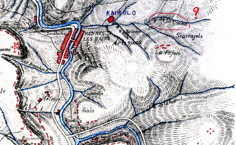
copyright: http://www.rennes-le-chateau-archive.com/boudet_ses_ecrits.htm
For some the mysterious 'room of amphora' would be located in this general area.
In chapter 8 of LVLC which Boudet called CELTIC HOUSEHOLDS - The road for the Chariots
he continued:
The Celts took advantage of the declivity of the slopes to build part of their houses in the ground, to which they gave the round shape. They were, say the authors, very spacious, built of wood and earth, covered with thatch or chopped straw and kneaded in clay.
It is quite possible that the poorer houses were well covered, but it is difficult to believe that the Gauls might know not to use the tiles, they left us in the name rajole, rash, rash, and dialect Languedoc, flow, hole, small housing, which means the brick today.
Close to Artigues and above Bugat, part of the land is named scarrajols, square (skouère),square, rash, discharge, hall (Haull) home. It is there, the square tile with hooks, which is in considerable quantity, on several points, in the cromleck of Rennes-les-Bains. Undoubtedly, Scarajols does not indicate to us the more or less distant period in which these tiles were made, but why should we refuse obstinately to the Celts the most minute degree of civilization and attribute to them, without reason, an ignorance which their language constantly contradicts? The Numidians, Sallust reports, do not they covered their channel tile mapalia? It is of little consequence whether the scarrajols were a tile factory or a house covered with tiles, it is sufficient to observe that the Gauls could use either stubble or tiles for the drainage of rainwater on the roof of the house. We arrived at the Gallic village by the road drawn at the foot of the mounting of Cardou and which rises in a gentle slope until opposite the thermal resort from where it ends up in the center of Artigues. This path had a certain width, as the name of the Col de Bazel tells us, and the wagons could thus reach the interior of the village.
Buildings made of wood and clay were certainly not very costly; So they existed in the story. In the middle of the eastern slope of the mountain which looks towards Rennes-les-Bains, and on a point near enough to the hamlet of the circle, is a large rock, cut so as to form three sides of a square house. The field in which this rock is stood, is named Gléizole, clay (key), clay, to ease (ize), issue, hall (Haull) home. This house, freed from the clay commonly employed in the construction of Gallic dwellings, shows by its square form it is from the Gallo-Roman period.
Northwest of the Borde-Neuve, between Foucilhe, the embarrassed hill was (feuss), embarrassment, hill, hill, and Roucats, the portion of land called Siala, to see (if), view, hall,house , Possessed, as its name indicates, a few Celtic mansions. The artigue word assigned to the houses of the Celts, still exists in the Languedoc dialect, and when a farmer clears a part of a timber, it is said that a Artigot, although he now intends to build a field there, rather than build a house there.
At the foot of the Celtic town of Artigues and near the stream of Coume, we see a circular site called Salasse, dirty, market axis ax. It was the market, the public square, where ordinary trade, sales, and purchases of domestic trade took place.
The Roucats, (to ronghcast), sketch, we quoted, speaking of Siala, extends to the right bank of the Sals, is filled with ménirs drafted, superimposed stone tables together and made Part of the inner circle enclosed in the cromleck of the Redones. On the banks of the Sals and in the Roucats, there is a part of the Celtic road that leads to Bugarach. The width of this path can easily be measured by the menirs which still surround it. At the precise point where the road, along the river, penetrates into the wood of the Roucats, two small Greek crosses, covered with moss, are visible on two rocks, placed to the right and left of the Gallic road, Without doubt, the importance of the numerous menirs scattered on the flanks of the hill".
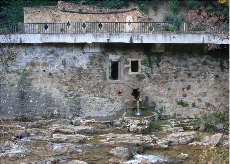
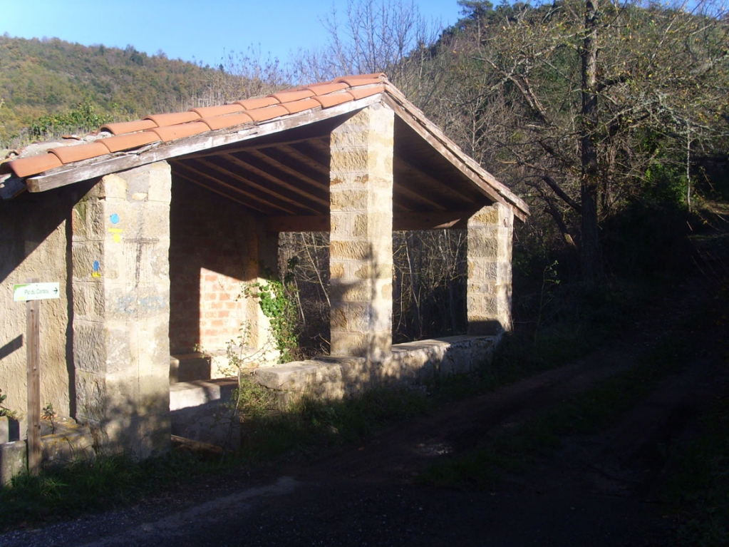
Montferrand would be the important place for Boudet perhaps. And in fact, when one looks at the Births, Marriages and Deaths documents of the seventeenth and eighteenth centuries; one can see how much bigger Montferrand was - as was Sougraigne, and you can see that the people used to walk or ride between the two, especially the shepherds. Montferrand was certainly inhabited enough to support the building of a lavoir, or washing place, for the use of the village women. The hamlet was probably built around this natural spring, in Celtic and then Roman times, when you remember that the water in the valley was thermal or salty.
It is this knowledge which brings us back to the statement cited above and made by Urbain de Larouane. Remember he has written that L'ancien village de RLB situé vers le Bazel et les ancien thermes ont été décrits' - then described a "salle carrelée de la source de la Saponaire, amphores romaines" which means 'a tiled room of the source of the Saponaire [cockle], [with] Roman amphorae".
Larouane seems to be recounting the old celtic village referred to by Boudet in the vicinity of Bazel/Montferrand. We see that Boudet talked of many tiles making up houses. The source of the Saponaire would be linked to water that 'soaps' up, a particular trait of the plant the Saponaire. It is a plant of the herbaceous perennial family Caryophyllaceae . It is also called savonnaire, soap dish, saponière, soap grass, grass Fuller, soap ditch or pit soap. The genus name Saponaria derives from the Latin sapo ("soap") and -aria ("pertaining to"), and at least one species, S. officinalis, has been used to make soap. It contains saponins, and a liquid soap could be produced by soaking the leaves in water. This soap is still used to clean delicate antique tapestries. This plant has purgative, diuretic , choleretic and medicinal properties. It is used against rheumatism and gout, against certain skin diseases and as an expectorant for the affections of the oral cavity (tonsillitis, mouth ulcers, etc). Saponaire applied on the face provides effectiveness against skin diseases such as acne . The Romans put it in the baths to cure itching. Leper colonies used it to clean the wounds of lepers.
This would have been a most wondrous source for the Celts and Romans would it not?
And where was it? Montferrand.
Montferrand was certainly inhabited enough to support the building of a lavoir, or washing place, for the use of the village women.
he continued:
The Celts took advantage of the declivity of the slopes to build part of their houses in the ground, to which they gave the round shape. They were, say the authors, very spacious, built of wood and earth, covered with thatch or chopped straw and kneaded in clay.
It is quite possible that the poorer houses were well covered, but it is difficult to believe that the Gauls might know not to use the tiles, they left us in the name rajole, rash, rash, and dialect Languedoc, flow, hole, small housing, which means the brick today.
Close to Artigues and above Bugat, part of the land is named scarrajols, square (skouère),square, rash, discharge, hall (Haull) home. It is there, the square tile with hooks, which is in considerable quantity, on several points, in the cromleck of Rennes-les-Bains. Undoubtedly, Scarajols does not indicate to us the more or less distant period in which these tiles were made, but why should we refuse obstinately to the Celts the most minute degree of civilization and attribute to them, without reason, an ignorance which their language constantly contradicts? The Numidians, Sallust reports, do not they covered their channel tile mapalia? It is of little consequence whether the scarrajols were a tile factory or a house covered with tiles, it is sufficient to observe that the Gauls could use either stubble or tiles for the drainage of rainwater on the roof of the house. We arrived at the Gallic village by the road drawn at the foot of the mounting of Cardou and which rises in a gentle slope until opposite the thermal resort from where it ends up in the center of Artigues. This path had a certain width, as the name of the Col de Bazel tells us, and the wagons could thus reach the interior of the village.
Buildings made of wood and clay were certainly not very costly; So they existed in the story. In the middle of the eastern slope of the mountain which looks towards Rennes-les-Bains, and on a point near enough to the hamlet of the circle, is a large rock, cut so as to form three sides of a square house. The field in which this rock is stood, is named Gléizole, clay (key), clay, to ease (ize), issue, hall (Haull) home. This house, freed from the clay commonly employed in the construction of Gallic dwellings, shows by its square form it is from the Gallo-Roman period.
Northwest of the Borde-Neuve, between Foucilhe, the embarrassed hill was (feuss), embarrassment, hill, hill, and Roucats, the portion of land called Siala, to see (if), view, hall,house , Possessed, as its name indicates, a few Celtic mansions. The artigue word assigned to the houses of the Celts, still exists in the Languedoc dialect, and when a farmer clears a part of a timber, it is said that a Artigot, although he now intends to build a field there, rather than build a house there.
At the foot of the Celtic town of Artigues and near the stream of Coume, we see a circular site called Salasse, dirty, market axis ax. It was the market, the public square, where ordinary trade, sales, and purchases of domestic trade took place.
The Roucats, (to ronghcast), sketch, we quoted, speaking of Siala, extends to the right bank of the Sals, is filled with ménirs drafted, superimposed stone tables together and made Part of the inner circle enclosed in the cromleck of the Redones. On the banks of the Sals and in the Roucats, there is a part of the Celtic road that leads to Bugarach. The width of this path can easily be measured by the menirs which still surround it. At the precise point where the road, along the river, penetrates into the wood of the Roucats, two small Greek crosses, covered with moss, are visible on two rocks, placed to the right and left of the Gallic road, Without doubt, the importance of the numerous menirs scattered on the flanks of the hill".
Montferrand would be the important place for Boudet perhaps. And in fact, when one looks at the Births, Marriages and Deaths documents of the seventeenth and eighteenth centuries; one can see how much bigger Montferrand was - as was Sougraigne, and you can see that the people used to walk or ride between the two, especially the shepherds. Montferrand was certainly inhabited enough to support the building of a lavoir, or washing place, for the use of the village women. The hamlet was probably built around this natural spring, in Celtic and then Roman times, when you remember that the water in the valley was thermal or salty.
It is this knowledge which brings us back to the statement cited above and made by Urbain de Larouane. Remember he has written that L'ancien village de RLB situé vers le Bazel et les ancien thermes ont été décrits' - then described a "salle carrelée de la source de la Saponaire, amphores romaines" which means 'a tiled room of the source of the Saponaire [cockle], [with] Roman amphorae".
Larouane seems to be recounting the old celtic village referred to by Boudet in the vicinity of Bazel/Montferrand. We see that Boudet talked of many tiles making up houses. The source of the Saponaire would be linked to water that 'soaps' up, a particular trait of the plant the Saponaire. It is a plant of the herbaceous perennial family Caryophyllaceae . It is also called savonnaire, soap dish, saponière, soap grass, grass Fuller, soap ditch or pit soap. The genus name Saponaria derives from the Latin sapo ("soap") and -aria ("pertaining to"), and at least one species, S. officinalis, has been used to make soap. It contains saponins, and a liquid soap could be produced by soaking the leaves in water. This soap is still used to clean delicate antique tapestries. This plant has purgative, diuretic , choleretic and medicinal properties. It is used against rheumatism and gout, against certain skin diseases and as an expectorant for the affections of the oral cavity (tonsillitis, mouth ulcers, etc). Saponaire applied on the face provides effectiveness against skin diseases such as acne . The Romans put it in the baths to cure itching. Leper colonies used it to clean the wounds of lepers.
This would have been a most wondrous source for the Celts and Romans would it not?
And where was it? Montferrand.
Montferrand was certainly inhabited enough to support the building of a lavoir, or washing place, for the use of the village women.
The old water source and [below] the lavoir of Montferrand.
This source of the Saponaire is frequently referred to by French researchers. In February 2016 the following exchange took place HERE involving subscribers to the Forum under the names of Grominet and Raoul.
Grominet wrote [06 Fév 2016, 20:28]:
Il y a au moins 2 choses à retenir de ce que dit l'abbé Lasserre :L'arrivée de Missionnaires (qui, comme l'abbé Boudet le signale également) vont, sur l'ordre de "St Paul Serge" graver des croix (certes) mais "il est incontestable...que les Missionnaires chrétiens trouvèrent ces petits monuments païens..."(Lieux sacrés).
https://archive.org/details/rechercheshistor00lass encore merci Georges
Mais aussi (798 ? en vous demandant de vérifier car je n'ai pas la notice sur ND de Marceille) en soustrayant à la rage des musulmans un riche dépôt. S'en suit la transmission d'un "secret".
Le Pontet est, en plus de la "saponaire", intriguant car ceci supposerait un petit pont reliant les 2 rives de la Sals. L'axe principal est le long du Cardou.
Une recherche facilitée pour les bulletins de la SESA :http://www.sesa-aude.fr/Liste-des-commu ... -par-nom-d, Rancoule est excellent notamment pour les monnaies trouvées dans le secteur."
Roughly translated this says:
"There are at least 2 things to remember from what Father Lasserre says: The arrival of Missionaries (who, as the Abbé Boudet also points out) will, at the order of "St Paul Serge", engrave But "it is incontestable ... that the Christian missionaries found these little pagan monuments ..." (Holy Places). Https://archive.org/details/rechercheshistor00lass yet thank you Georges But also (798? Asking you to check because I do not have the notice on ND de Marceille) by subtracting from the rage of the Muslims a rich deposit. It follows the transmission of a "secret". Le Pontet is, in addition to the "saponaire", intriguing as this would assume a small bridge connecting the two banks of the Sals. The main axis is along the Cardou. A search easier for the bulletins of the SESA: http: //www.sesa-aude.fr/Liste-des-commu ... -par-nom-d, Rancoule is excellent especially for the currencies found in the sector. "
This was followed by Raoul who replied:
"pour infos un message de JC de 2009
La réalité est tout autre pour la grotte- C'est l'ancienne grotte votive ou coulait la source dite la saponaire, cette grotte est pratiquement innacécible puisque effondrée sur la totalité de l'entrée - Il ne reste qu'un passage qui se bouche de plus en plus avec le temps - Cette grotte contenait des amphores allait se servir un habitant de Rennes les Bains qui les vendait un bon prix dans les années 50 ( moi c'est Georges Delmas qui m'avait indiqué cette grotte) son fils Robert est aussi au courrant - Cette grotte est grande comme la moitié de la place de Rennes les Bains et en partie carrelée ou plus exactement empierrée avec des dalles de grès plus ou moins régulières - J'espère que personne ne pillera cette grotte“
My rough translation:
For a message of JC of 2009 - The reality is quite different for the cave - It is the ancient votive grotto or the source called the saponaire, this cave is practically inaccessible since it collapsed on the whole entrance - There is only a passage that clogs More and more with time - This cave contained amphoras was going to serve a resident of Rennes les Bains who sold them a good price in the fifties (it is Georges Delmas who had indicated to me this cave) his son Robert Is also current - This cave is large as half of the place of Rennes les Bains and partly tiled or more exactly stone with sandstone slabs more or less regular - I hope that nobody will plunder this cave.
JC later went on to say - I confirm the existence of not a temple but a cave covered with large tiles - I objected that the place is specified so that it is not stolen, that being said there are a few amphoras that are broken for the vast majority of those who were fit were stolen from there it long ago - I think that this cave was a place of worship, there flowed there a source that the people of RLB and Montferrand called the saponaire - This cave was abandoned or forgotten after the collapse of the entrance and also because the people of Montferrand later lived more further down - that is to say, RLB. In terms of the time very clever one who can say, it makes me a little thought to the cave to the twelve sculpted heads Camps / Agly- Although difficult to describe the pavement of this grotte- These are paving shapes square gray color and covered 90% of mud, there seems to be a kind of sandstone - I repeat this cave collapsed and must be accessed on all fours and in places it is impossible to pass. The entrance was open when it had to make a dozen meters wide and 4/5 meters of - There would appear to be a landslide that had blocked the entrance - There are around 15 years I was staying with my friend Bernard, told him it was more important that I dit- The spring flowing in the pelvis was right inside the basin is completely dry now " Michel Gaillot had found the place where it flowed out, today there is no trace of water outside " Ideally, a team of young and mostly slender can explore the scene to the end, we have only the side accessible for amateurs 90 kg"
And now we come full circle because it would now seem that this was the cave entred by Cherisey/Charlot. For he wrote in CIRCUIT the following:
"The journey of Charlot and Marie-Madeleine lies through a land that appears torn by accidents of nature. A landscape marked by the contrast between dark rock and of white rock.
Marie-Madeleine: And "PAX DCLXXXI" what does this all mean?
Charlot: If you translate it into Arabic numerals it gives 681, a play upon the number 1,681 and with 1861, the date of the Delacroix painting. Historically the 17th January 681 marks the arrival in Rennes of the "Rejeton Ardent", the son of king Dagobert II. He is the Lorraine survivor on the white horse of Meroveaus Levi. As regards PAX, it is the inscription of peace [or on the Labarum], the golden oriflamme preserved at Saint-Benyon [Denis] - the red flag who will lead us on to victory.
Marie-Madeleine: Then what must I do?
Charlot: Assist me, wherever it might be, and the place that I mark with a cross on the map in whatever way, I will be able to find it. [Wait here, or over there, at the place i marked with a cross on the map. In any event i will find you].
Landscape of rocks and of thorns. Charlot, strips to his waist and grovelling on all fours in a rugged sloping crevice - he climbs a rough slope - carrying, for his only baggage two electric pocket torches.
Charlot: I salute all you others, an explorer of Montferrand and of Cardou riddled with tunnels in the churches and cemeteries!
After a last and rapid glance at the landscape he penetrates boldly into a crevice/crack [called a catin] where one would pass by a thousand times without discovering/noticing it. The way forward is via a narrow neck. After a brief journey, which seemed never ending, there is a branching tunnel/junction in a pool [or cesspit]. Cellis or Arcis? Right or left? Lets go for the left and long live the King. He enters, crawling flat on his stomach into a whitish mineral patina the fumes from which brings tears to his eyes and makes him cough... After about thirty metres he meets a smooth and vertical wall where the previous stalwarts had carved several niches as footholds. At the sixth niche there is a small gully of running water: Charlot almost loses his balance. His knee knocks harshly against the stone. He scrambles painfully to the top, onto a solid rock platform across which he moves forward like a limping ghost, plastered with smears of white and the blood which trickles all the way down his leg.
The sepulchre of the Great Roman stands in the centre of the platform, immediately beneath where the arches of the high vaulted ceiling cross. Two inscriptions on the memorial pedestal upon which the lead coffin, tightly sealed, show not the least signs of damage. Charlot kisses the coffin. As regards to treasure, there is not the slightest trace, except in the partitions of the vaulted arch, where there is perhaps a faint glimmer of copper. Several cellar rooms extend for some distance but they stretch beyond the light of his torch/lamps' beam. There is a deadly passage under a crumbling arch. Here is the right hand passage that Charlot thanks heavens for having avoided.
The cellars are flooded right up to knee height but there is one that he can get through on all fours along a narrow lateral wall that is made up of tiles that have been piled, one upon the other, without any bonding/cement. The whitish ceiling is rather crumbly. Prudent progress is important. Charlot stops in order to take a breather and lights his second lamp,and, here it's the old story of killing time, just to see how the tilers of ancient times worked, so he picks up a tile.
It is a very heavy tile because it is made of gold which showed up when one scrapes the scum off with a finger nail. With just one tile like that it would provide the means of living comfortably for two years, and there is miles of them here, so much, say some, as recounted in the ballads of Arab. But to drag this one tile, all the way back on hands and knees when you are in the cold and can see behind you this small trickle of blood which already marks out the route, then the life one has left behind becomes more beautiful, life is not fun anymore What merde!
Charlot - bloody hell
The echo: Merde! Hell!
He replaces his tile on the little wall, from where he took it, and covers it with dust, just as he found it, pursues his journey in the cellar and reappears from behind the tomb of the Grand Roman, the way he had come. The smooth wall that he once had scaled, if with some difficulty, now seemed precipitous to Charlot making him dizzy at the prospect of descending. So he decided to select an alternative route. The route leads to a passage with light at the end of the tunnel. Here comes the horror: the cavern which leads to the light is the residence of the sentinels of the Grand Roman. These are the dead, trapped in a hole - who wave their tiles just as the dregs of humanity would brandish their steel as they hone their blades. These are the dead of some very different era, there is among them some perfect skeletons, and some faces so well preserved by the atmospheric conditions that one would say that they were stars from a Grevin museum.
Charlot: Terribilis est locus iste.
He infiltrates among the dead, slips on a tibia bone, bangs his head against a skull which detaches from its trunk with a dry crunch. His hand looks for a support and finds a round object, a piece of coinage. The glaring rays of the sun strike into the cave illuminating various pots that have been heaped up. Here is the deposit of a small millionaire priest. Once again illuminated by lamplight. Charlot crouches over the empty vessels. This is a place of death, in the distance stands a beautiful ruin, the guardian of the sword. Over there down below it must surely be the bright dress of Marie-Madeleine, but she is turned facing in the opposite direction so she could not see the lamp signal. Despite the shouting, she doesn't hear.
Returning on foot toward the interior, Charlot sees that there is a galley descending in a gentle slope. He crawls more than he walks. His eyes burn. His breathing becomes difficult. And then the passage comes to a dead end. He cries out, falls, gives another shout and feints. Marie Madeliene heard the voice which seems to emanate from beneath a large rock. She clears away some undergrowth, small stones and some topsoil. After a great struggle she manages to extract this poor old young Lazarus revived/ from the dead amidst all of those other corpses. She washes off all his white mud and tends his injuries. She wraps him in a sleeping bag, and offers him a sip of rum. Thank you!
Marie-Madeleine: The most beautiful girl in the world could not offer more than that which she has at this moment.
Charlot: Not so. She doesn't give it. She lends it: I have lived, I know what I am saying.
Marie-Madeleine: How much do you bet?
Charlot: Nothing I am poor.
Marie-Madeleine: Was there no treasure at all?
Charlot answers that there was one there, very powerful, and another fabulous, that there was enough to sustain several empires, but that he would rather die than touch it. We must wait until someone from the rond de lis [The ring of the Lily or fleur de lis circle] comes to reclaim it or there appears an honest head of state - that could take quite some time.
_________________
As i now saw - back in 2009 it seems researchers talked of a mysterious cave or 'grotto'. Under the thread title of Order of the Temple, on Febuary 4, 2009, 10:35 a poster wrote:
"I think Plantard made a true story perhaps into another story, as was his habit. It is true that a certain Dubosc came to do an inventory of the mines of Roc-Negre. The 'story' of the round temple is located between Roc-Negre and Rennes les Bains, [but] the reality is something else. There were two people in the 80's who knew the place of this temple. One died, Mr Carrère who fetched amphorae in this place and resold them for a good price.
The second person is still resident at RLB and made the description of the place in front of witnesses last year [i.e 2008]. He described the temple as a great place of Rennes les Bains and said that it is tiled with 40x40 paving stones in gray marble. This person is friends with Blanchefort - he gives us the exact location of this temple. From our conversation it is actually an ancient cult cave whose entrance has collapsed and where it is difficult to enter. This cave or temple is not between Roc-Negre and RLB but on the Cardou side. The error of the location of the place probably comes from the fact that the current road is recent, as the old road, passed in front of Bazel. It seems that the priest Delmas also talks about this place".
Cardou then wrote on "February 4, 2009, 12:15
Hello all - I confirm the existence of not a temple but a cave covered with large tiles - I object that the place is specified so that it is not stolen, that being said there are a few amphoras that are broken for the vast majority of those who were fit were stolen from there it long ago- I think that this cave was a place of worship, there flowed a source that people RLB and Montferrand called the saponaire- Especially do not believe whether it is the tomb of Mary Magdalene.
You know as well as I that the journal Vaincre is the work of Plantard -
You mean what picture? If that's the one I put on the site a few years ago you know it is a place that Boudet call Lampos - For the round temple, it is an interpretation of Plantard, the cave that I know is not round, it's more or less a square surface - At [?] Lampos there is the entrance to a room that old familiar Serres (Emile) I seem to remember that Jdrouen also knows this room - I have never had a memory, and to my dismay I lost all my archives, thank you for your reply.
And later:
L'amiral Cagère était un ami du père de Jean Lecousse qui lui était médecin militaire général en Indochine- (la rencontre de ces deux hommes s'est faite en Indochine)
Cagère semble s'être intéressé à RLC à titre personnel –
L'équipe Domergue, Lecousse, Navet, jojo Martin, viennent à RLC suite à la connaissance de Cagère Lecousse en 1954 à cette époque Plantard est inconnu à RLC-
Le 17 janvier j'ai demandé à J-Lecousse si Plantard venait à RLC à cette époque, il m'a dit que NON -
Il est donc possible que Plantard soit venu suite à une rencontre faite à Gisors !?
Admiral Cagère was a friend of the father of Jean Leconfield which he was general military doctor Indochina- (the meeting of these two men was made in Indochina)
Cagère seems interested in RLC personally - The team Domergue, Leconfield, came to RLC following knowledge in 1954 at this time is unknown Plantard RLC- On January 17, I asked J-Leconfield if Plantard knew about RLC at that time, he told me that NO - It is therefore possible that Plantard came following a meeting made in Gisors?
March 8, 2009, 11:39
I think the story of the round temple is an invention of which I know nothing- The only reality is that there is a network where the pass called Bains Doux which is also mentioned in the book by doctor Courrent-
Rex Mundi had found a place where the water passes by nature, this place was cemented at the time by the Marquis De Fleury - The network is very large since it takes 8 hours to ensure that water in Rennes les Bains (experiment by Fleury) while the distance as the crow flies is 1500 meters from the place cimenté-
The votive grotto is not at all in the same place, it is listed Cardou - It is not round but vaguely (an oblong) and all rest assured there are no grave or coffin inside- Right inside the cave there are the old fountain that flows more and mud layer on the what-if area There long since the amphoras were looted it remains to this day what that broken amphora on the part accessible- The other part would be accessible by cavers threadlike which is not my case ".
________________________________
It would certainly seem that there are more discoveries to be made at Rennes-les-Bains. It would also seem there are several different 'things' to be found. The more one reads the more one starts to ascertain the slight differences in what is being referred to. The poster JC felt that the cave he had heard about was sacred but there is no reason why it could not have been perhaps a horreum which was a type of public warehouse used during the ancient Roman period. Although the Latin term is often used to refer to granaries, Roman horrea were used to store many other types of consumables; the giant Horrea Galbae in Rome were used not only to store grain but also olive oil, wine, foodstuffs, clothing and even marble. The first horrea were built in Rome towards the end of the 2nd century BC, with the first known public horreum being constructed by the ill-fated tribune Gaius Gracchus in 123 BC. The word came to be applied any place designated for the preservation of goods; thus it was often used refer to cellars (horrea subterranea), but it could also be applied to a place where artworks were stored, or even to a library. Some public horrea functioned somewhat like banks, where valuables could be stored, but the most important class of horrea were those where foodstuffs such as grain and olive oil were stored and distributed by the state. There was a famous horreum at Narbonne and this complex is at some five meters below street level. The Horreum is the only building dating from classical times that can still be seen in Narbonne. It is a former underground warehouse and dates from the end of the first century BC and was probably the below-ground section of a market. Stone remains have been put on display in the alcoves that open off the north wing to remind visitors of the splendours of Narbo Martius.
Another point of interest would be how something that was revered as sacred would have been lost? And if it was lost then one could ask how that knowledge was found again? Anyway, this short delve into the local history of Rennes-les-Bains was just to illustrate a point - that perhaps all the disparate writings helped Cherisey find the 'sacred cave' and was therefore able to visit it? Because the description in Circuit in the chapter L'ALIBI D'O' seems rather to literal to have been invented?
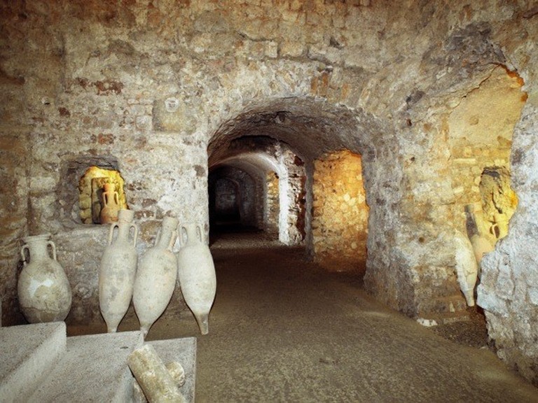
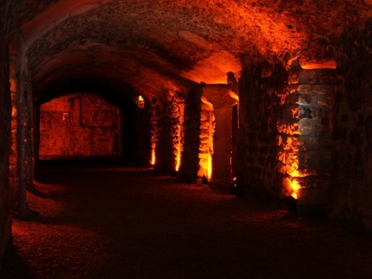
Above - the underground horeum at Narbonne.
SAH 23/11/16
The natural follow up to this article, while looking at landmarks on Boudet's Rennes Celtique map will be looking at the topographical 'errors' Boudet has made. Deliberate clues or deliberate stupidness?