About the seven pieces of land purchased by
Bérenger Saunière
That dogged researcher Patrick Mensior has yet again raised a very interesting point. He has given me permission to report it on this website. Merci Patrick.
On page 24 of the Mythology of the Treasure of Rennes (Ed. Collot 1991), René Descadeillas referred to seven pieces of land purchased by Bérenger Saunière through his maidservant Marie Dénarnaud. Descadeillas wrote: "Between 1898 and 1905, he [Saunière] gained from several people under-developed land located south of the church and rectory and around the mountainous plateau edge." The total price of this land is marked by the priest
in a letter dated 14 July 1911 addressed to Mr. Vicar General.
René Descadeillas and Gérard de Sède are in agreement on the sum total of these acquisitions but not on the number of the pieces of land. Descadeillas refers to the acts of the Conservation of Mortgages at Limoux [which counts 7] while the second, referring to a handwritten note by Saunière, speaks 6 pieces of land. Therefore there is a difference in the amount and cost of the land between the historian of Rennes and Saunière himself. René Descadeillas gives 110frs, 600 frs to 40 frs while in the details by the Saunière the amounts paid are missing.
Anyway, René Descadeillas, who was referring to official documents while Saunière was probably relying on his memory for information seems the more reliable. To this we need to add the nomenclature of the location and purpose of the land:
"At the same time, he [Saunière] bought old ruined barns & parts, lining the streets and facing the southeast of the rectory yard. In 1900, he began to build on the site of an old barn a "Villa" in stone. On the other side of the street, on a large piece of land he designed a garden, built a greenhouse and sheds. Between the edge of the rocky plateau and the boundary of the cemetery and the church, the priest began his greatest work - he rebuilt the old wall of the ancient village, surrounding the village. At each end [of the wall] he built a tower. And in the space in between, well fenced, he designed a garden."
Patrick investigated a bit further. After checks on different Cadastral survey maps, it appears that René Descadeillas did not check through the cadastral documents to see the exact location of the lands Saunière bought - for it turns out that the lands bought could be quite different from those he describes in the village and that to match the time of purchase with the constructions of the priest as well as the land surveys is problematic. This raises interesting questions on the totality of the land he bought and where. Have i interpreted correctly?
For Mensior, René Descadeillas failed to specify which precise section of the Cadastre was important. The Napoleonic cadastre, which forms the following matrix, was completed October 30, 1831 by the two surveyors Mr. St Priest and M.Lallemand. It consists of 3 sections with as many sectors -the 3 sections are labelled A, B, and C; these sections themselves are divided into two or three sub-sections: A1, A2, B1, B2, B3, C1, C2, and C3 up to 8 in all. There is some confusion as the same number of pieces, & their numbers are the same from one section to another. Only letters of the section (A, B or C) differentiate them. And it is this last point that is missing.
The plots purchased by Saunière all have numbers above 500, so they cannot be identified with those located at selected locations in the centre of the village. Was there another cadastre map used then? The priests' constructions, according to Descadeillas, are on plots that are all numbers in one or two digits as shown on the Map below - the 1831 Napoleonic cadastral and the most recent one of 1940.
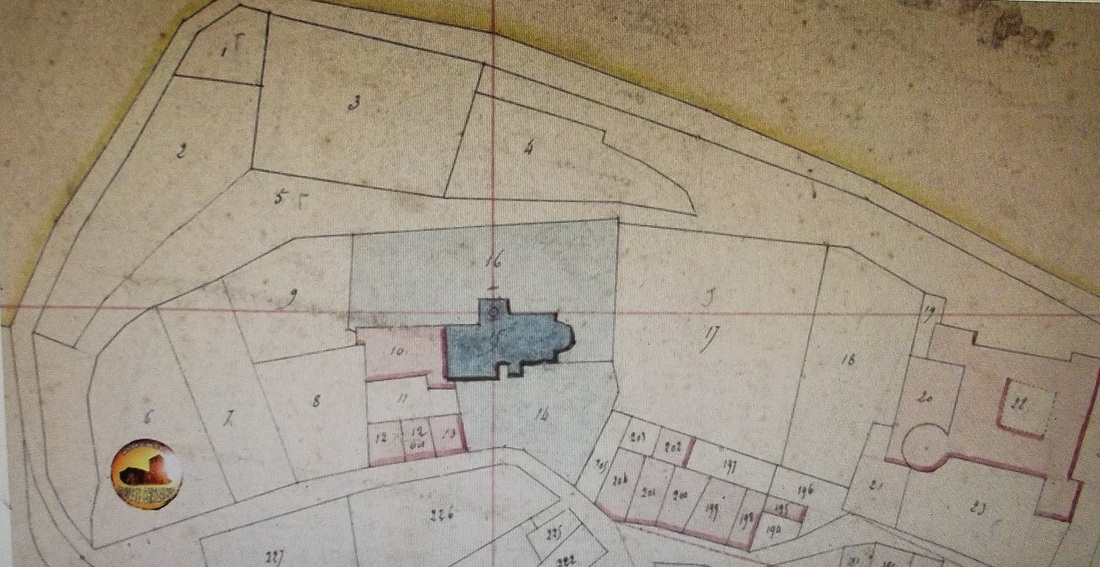
Napoleonic cadastre of 1831 - here we can see the places where Saunière purchased land and then built on it. Descadeillas reported "he began to build on the site of an old barn a "Villa" in stone. On the other side of the street, on a large piece of land he designed a garden, built a greenhouse and sheds. Between the edge of the rocky plateau and the boundary of the cemetery and the church, the priest began his greatest work - he rebuilt the old wall of the ancient village, surrounding the village. At each end [of the wall] he built a tower. And in the space in between, well fenced, he designed a garden". We can see from the cadastral map which was in use in 1831, 67 years later when Saunière purchased the first land - that the numbers allocating the plots of land Saunière bought number 5, 6, 7, 8, 9, 10, 11,12,13, & perhaps 226,227 etc.
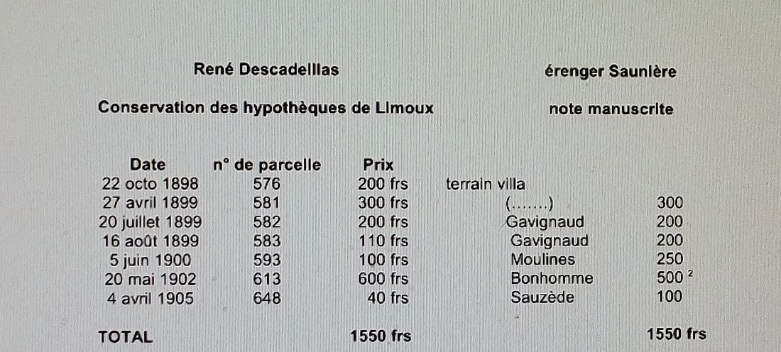
To the left, the notes made by Descadellas for his book the 'Mythology of the Treasure of Rennes' listing the dates Saunière bought the land and which parcel of land and how much he paid. To the right is a column by Saunière listing the land he bought [with the names of the individuals he presumably bought the land from?] but with no details of the location of the land. How does Descadellas list match up with the 1831 cadastral survey, the one in use when the land was bought?
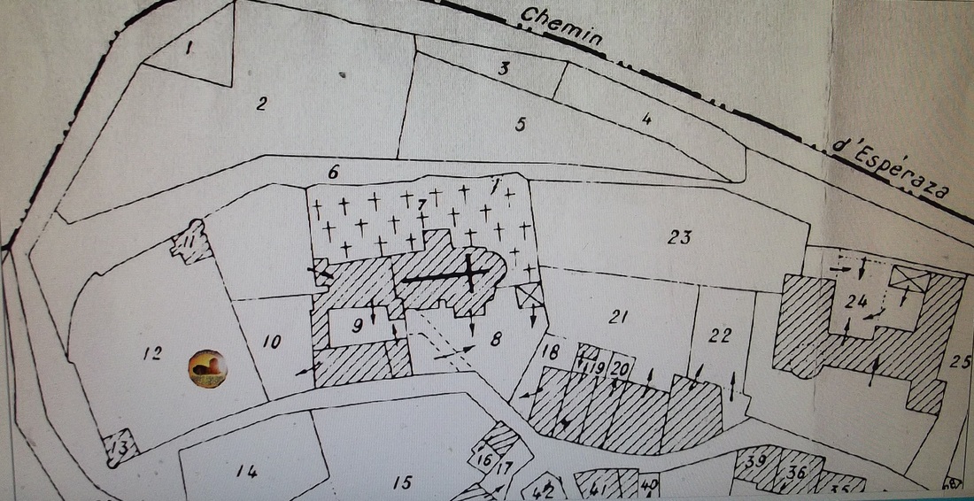
Here is the Cadastral map from 1940. Here we see the parcels of land bought in and around the village numbered 6 [?], 10, 11, 12, 13, 14 & 15.
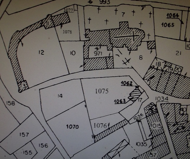
This image was photographed from the geoportail.fr site - showing an up-to-date cadastral survey. One can see here the areas of land once owned by Saunière are now numbered 10, 11, 12, 13, 14, 1070 & 1075. This photo was taken 23/3/2015.
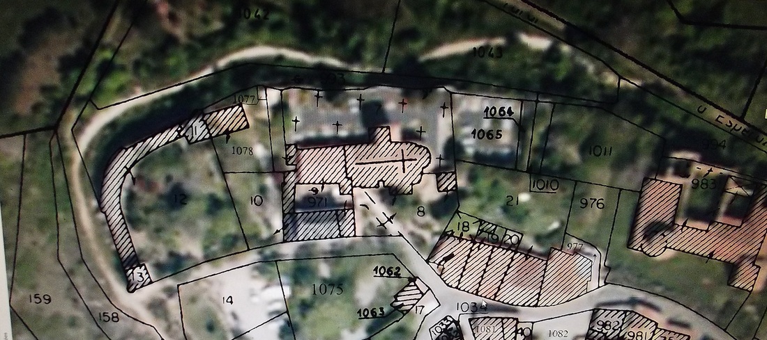
The modern cadastral map overlaid on the ground.
So in the list of the parcels of land that Descadeillas refers to - which bit of land does this correspond to on the ground? Again Patrick suggests an answer. For example, under the section of A1 on the survey map, the area being signified starts from the edge of the village and goes north up to Founbit and Roque Fumade - & to the west Encantade and Le Bourg. The parcels of land of Sauniere and the corresponding numbered parcels of land indicate 5 found in the section called Croix del Bas and one by Serre Blanche and the last at Moulin. These are marked below by the glyph of Patrick's website.
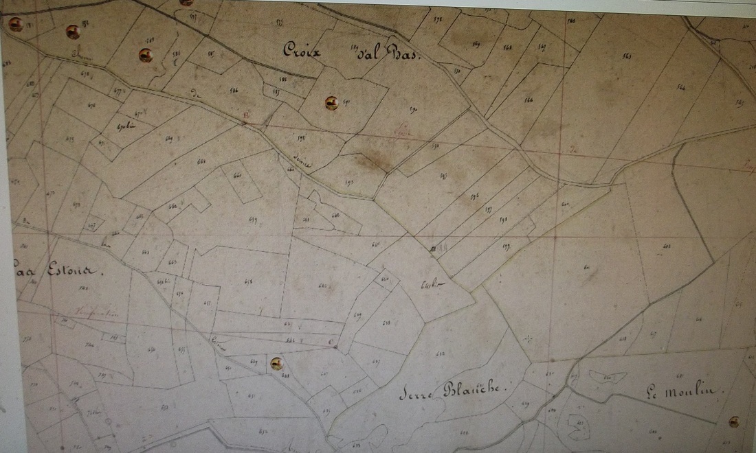
Here Patrick has indicated the parcels of land [possibly? or definitely - it is not clear] under the cadastral section of A1.
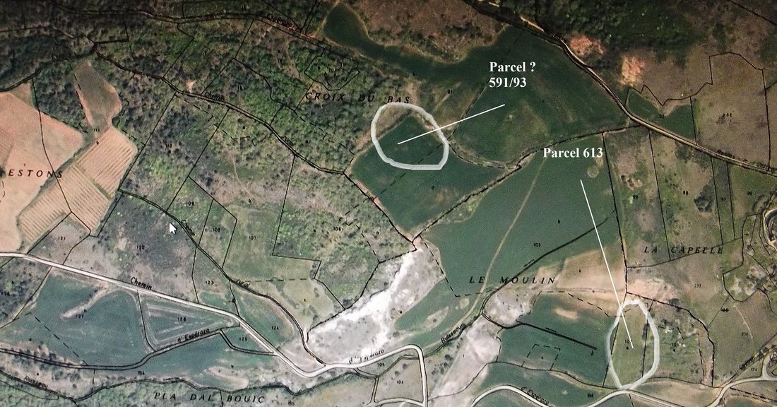
The terrain today approximately matching some examples of the parcels of land on the old cadastra's that Sauniere purchased.
Above is the modern cadastre map laid over the terrain and which approximately locates the areas Patrick has cited on the 1831 cadastre map as being purchased by Sauniere.
Another example is the Section labelled C2. This corresonds to a section of land just south east of the village of Rennes-le-Chateau. It's limits are La Bordes, Capia and the hamlet of La Maurine and to the north - the road that comes from Rennes-les-Bains.
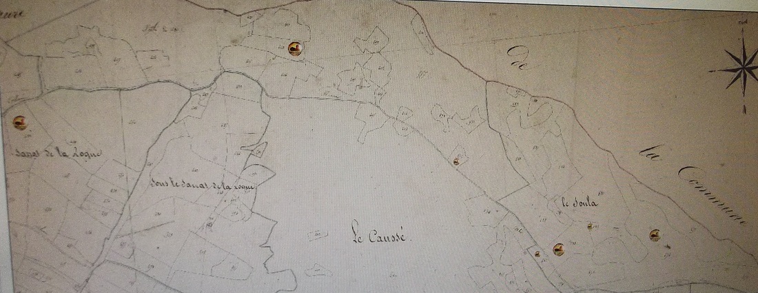
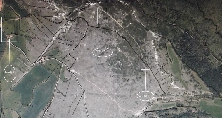
The C2 area - with the approximate possible locations of land purchased by Sauniere. One wonders if this may give substance to the assertion often given that Sauniere took to wandering the local countryside near to the village for hours during days out.
Here is the original document of Patrick Mensior regarding this fascinating work - where he details all the sites of the parcels of land Sauniere may have purchased:
| terrains_sauniere_1898_1905_(1).pdf |